Government Hill School — 1964 Earthquake Subsidence, Anchorage

This photo shows evidence of the subsidence at the Government Hill School location in Anchorage, caused by the 1964 Good Friday Earthquake.
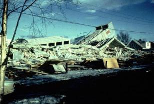
About This Photograph
This historical photograph documents the dramatic ground subsidence that occurred at the Government Hill School site in Anchorage during the magnitude 9.2 Good Friday Earthquake on March 27, 1964. The image captures the aftermath of one of the earthquake's most visible and scientifically significant effects in urban Anchorage—the large-scale failure and settlement of ground in areas underlain by sensitive marine clay deposits.
Government Hill is a neighborhood in north-central Anchorage that suffered severe damage during the 1964 earthquake due to its position on a bluff underlain by the Bootlegger Cove Clay Formation. This sensitive marine deposit, laid down in an ancient sea that once covered the area, is highly susceptible to liquefaction and flow failure when subjected to intense seismic shaking. During the earthquake's sustained four-minute duration, the clay beneath Government Hill partially lost its structural strength, causing the ground to shift and slump.
The school building itself was directly affected by this ground failure, with portions of the structure experiencing significant differential settlement as different parts of the building foundation moved at different rates. The dramatic collapse of ground in the vicinity of the school graphically illustrated how building location and underlying geology—not just structural design—determine earthquake vulnerability.
Fortunately, because the earthquake occurred on Good Friday afternoon, the school was not in session, preventing what could have been a catastrophic loss of young lives. The timing of the earthquake—a holiday afternoon when most public buildings were empty—was one of the primary reasons the death toll (131 total) was relatively low for an event of this magnitude and destructive force.
Ground Failure and the Bootlegger Cove Clay
The Bootlegger Cove Clay Formation is a marine deposit that underlies much of central and western Anchorage. Laid down approximately 10,000 to 25,000 years ago when the Cook Inlet basin was inundated by the sea, this clay is characterized by high sensitivity—meaning it can lose a large fraction of its strength rapidly when disturbed. Under static conditions, the clay is stable and has supported Anchorage's urban development for decades. However, the sustained intense shaking of the 1964 earthquake exceeded its threshold strength at many locations, triggering liquefaction and flow failure on a massive scale.
The most dramatic manifestation of this ground failure was the destruction of the Turnagain Heights neighborhood, where a large section of the city's western bluffs slid toward the inlet in a massive landslide that carried entire residential blocks into the water. Similar but smaller failures occurred at Government Hill, the Fourth Avenue district, and at the port facilities adjacent to Ship Creek. In total, ground failure caused by the Bootlegger Cove Clay was responsible for the majority of structural damage and deaths in Anchorage.
Post-earthquake geological investigations identified the distribution and characteristics of the Bootlegger Cove Clay in unprecedented detail, informing major revisions to building codes and land-use regulations throughout Anchorage. Subsequent construction in susceptible areas required deep foundation systems that bypass the sensitive clay layer and anchor into stable bedrock or dense glacial gravels below.