The 1964 Good Friday Earthquake
Content based on the account compiled by the Alaska Earthquake Information Center.
On March 27, 1964, at 5:36 p.m. ADT (03:36 3/28 UTC) a great earthquake of magnitude 9.2 (moment magnitude) occurred in Prince William Sound region of Alaska. The epicenter was about 10 km east of the mouth of College Fiord, approximately 90 km west of Valdez and 120 km east of Anchorage. The epicenter was located at Lat. 61.04N, Lon. 147.73W, at a depth of approximately 25 km. This earthquake is the second largest earthquake ever recorded in the world, after a M9.5 earthquake in Chile in 1960. The duration of rupture lasted approximately 4 minutes (240 seconds).
Cause
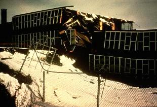
This photo shows evidence of the subsidence at the Government Hill School location, Anchorage.
The northwestward motion of the Pacific plate at about 5 to 7 cm per year causes the crust of southern Alaska to be compressed and warped, with some areas along the coast being depressed and other areas inland being uplifted. After periods of tens to hundreds of years, this compression is relieved by the sudden southeastward motion of portions of coastal Alaska as they move back over the subducting Pacific plate.
As a result of the 1964 quake, the Latouche Island area moved about 18 meters to the southeast. Also, the patterns of uplift and subsidence which had been slowly developing prior to the earthquake were suddenly reversed, with areas around Montague Island being uplifted 4–9 meters and areas around Portage down-dropped as much as 3 meters. The hinge line (line of no vertical change separating the uplift and subsidence zones) extended from near the epicenter in Prince William Sound to the SE coast of Kodiak Island. This vertical deformation affected an area of approximately 250,000 km² (100,000 miles²). The end result was the movement of the Pacific plate under the North American plate by about 9 meters on average.
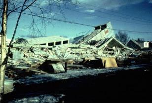
The six-story Four Seasons apartment building in Anchorage was completely destroyed. It was unoccupied at the time of the earthquake.
Aftershocks
The aftershock zone of this earthquake was about 250 km wide and extended about 800 km from Prince William Sound to the southwestern end of Kodiak Island. The mainshock and its aftershocks occurred on a fault which is part of the boundary between the Pacific and North American plates. Thousands of aftershocks were recorded in the months following the mainshock. In the first day there were 11 aftershocks with magnitudes greater than 6.0; in the next three weeks there were 9 more. Smaller aftershocks continued for more than a year.
Damage
The area where there was significant damage covered about 130,000 square kilometers. The area in which it was felt was about 1,300,000 square kilometers (all of Alaska, parts of Canada, and south to Washington). The four minute duration of shaking triggered many landslides and avalanches. Major structural damage occurred in many of the major cities in Alaska. The damage totalled $300–400 million dollars (1964 dollars).
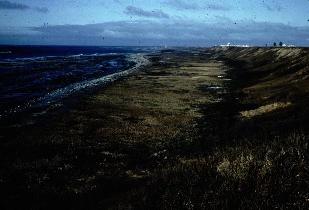
Middleton Island has repeatedly experienced earthquake-induced uplift, with 5 terraces visible from the last 800 years. The vertical uplift due to the 1964 earthquake was 3.6 meters.
Losses
The number of deaths from the earthquake totalled 131; 115 in Alaska and 16 in Oregon and California. The death toll was extremely small for a quake of this magnitude due to low population density, the time of day and the fact that it was a holiday, and the type of material used to construct many buildings (wood).
Water Waves
Much of the damage and most of the lives lost were due to the effects of water waves. These were mainly of two kinds: the tsunami of open-ocean sea wave, generated by large-scale motion of the sea floor; and the local wave, generated by underwater landslides in bays and fjords.
The 1964 Alaska tsunami was the second largest ever recorded, again following only the one caused by the 1960 Chile earthquake (4 meters at Sitka). Of the 119 deaths attributable to the effects of the ocean, about one-third were due to the open-ocean tsunami: 4 at Newport Beach, Oregon; 12 at Crescent City, California; and about 21 in Alaska. Local waves claimed at least 82 lives. Maximum height reported for these waves were 70 meters in Valdez Arm.
Seiches, a sort of sloshing of water back and forth in a small body of water like a boat harbor or swimming pool, were observed as far away as Louisiana where a number of fishing boats were sunk. Oscillations in the height of water in wells were reported from as far away as South Africa.
Seismic Waves
In addition to damage in the epicentral region immediately following the quake, long period seismic waves traveled around the earth for several weeks. Basically the whole earth vibrated (rang) like a church bell during this time. States as far away as Texas and Florida were affected with vertical motions of up to 5 to 10 cm.
Text composed by Doug Christensen, PhD, Geophysical Institute, University of Alaska Fairbanks.
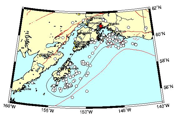
This map shows the location of the 1964 earthquake: star — epicenter; open circles — aftershocks occurred within 1 month after the mainshock; solid black line — estimated extent of the ruptured fault; red lines — mapped faults. Map composed by N. Ratchkovski.
Publications
The Alaska Earthquake Professional Papers
The U.S. Geological Survey published the results of investigations of the Alaska earthquake of March 27, 1964, in a series of six Professional Papers.
- Professional Paper 541 — An introduction to the story of a great earthquake: its geologic setting and effects, the field investigations, and the public and private reconstruction efforts.
- Professional Paper 542 — Describes the effects of the earthquake on Alaskan communities.
- Professional Paper 543 — Describes the earthquake's regional effects.
- Professional Paper 544 — Describes the effects of the earthquake on the hydrologic regimen.
- Professional Paper 545 — Describes the effects of the earthquake on transportation, communications, and utilities.
- Professional Paper 546 — A summary of what was learned from a great earthquake about the bearing of geologic and hydrologic conditions on its effects, and about the scientific investigations needed to prepare for future earthquakes.
Selected Other Publications
Grantz, A., G. Plafker, and R. Kachadoorian. 1964. Alaska's Good Friday earthquake, March 27, 1964, a preliminary geologic evaluation. USGS Circular: 491, 35 p.
Moore, G. W. 1964. Magnetic disturbances preceding the 1964 Alaska Earthquake. Nature 203:508–509.
Van Dorn, W. G. 1964. Source mechanism of the tsunami of March 28, 1964 in Alaska. Proceedings of the 9th Conference on Coastal Engineering, American Society of Civil Engineers 166–190.
Plafker, G. 1965. Tectonic deformation associated with the 1964 Alaska earthquake. Science 148(3678):1675–1687.
Page, R. 1968. Aftershocks and microaftershocks of the great Alaska earthquake of 1964. Bulletin of the Seismological Society of America. 58(3):1131–1168.
Brocher, T.M., et al., 2014. The 1964 Great Alaska Earthquake and tsunamis — A modern perspective and enduring legacies. U.S. Geological Survey Fact Sheet 2014-3018, 6 p.
Additional Resources
- Earthquake images
- Organizations
- Alaska Earthquake Center (University of Alaska Fairbanks) — statewide earthquake monitoring
- USGS Earthquake Hazards Program — earthquake hazard monitoring and research
- West Coast/Alaska Tsunami Warning Center — tsunami monitoring and warnings
- Multimedia
- Magnitude 9.2: The 1964 Great Alaska Earthquake — Short video by the USGS relating how the largest quake in U.S. history had profound and lasting impacts. Features USGS geologist George Plafker who, in the 1960s, correctly interpreted the quake as a subduction zone event.
- Though the Earth Be Moved — Documentary chronicling the first 72 hours after the 1964 Alaska Earthquake and the response by the Office of Civil Defense, U.S. Military, and government officials.
- Ocean Fury: Tsunamis in Alaska — Video by Alaska Sea Grant
- IRIS Animations (50th Anniversary, 2014)
- The 1964 Great Alaska Earthquake — Animation explaining the magnitude 9.2 megathrust earthquake, rupture processes, elastic rebound, and resulting tsunami.
- Tsunamis Generated by Megathrust Earthquakes — Uses examples from Japan, Chile, and Alaska.
- Tectonics & Earthquakes of Alaska — Describes the Aleutian subduction zone and the Denali earthquake.